Big Pine Creek in Indiana
|
Trip
Reports Excellent Trip Reports Available! |
Maps to Big Pine Creek |
|
The verbiage below was supplied by Indiana DNR's Canoe Guide. The information was last updated at least 16 years ago. Put-in points have disappeared and new ones have formed. It is very important that you submit any trip reports that you have and include what the put-in and take out points look like. With your help we can build a new and improved Indiana Canoe Guide. We will revise the information below as new information presents itself. |
 |
If
you have a favorite river, chances are that you know it best. You
can adopt a river for this site, then write about it and describe
the put-in points. You will get full credit and you will be doing
ALL Hoosiers a big favor.
|
|
Big Pine Creek combines natural beauty with a challenge for the canoeist. Like many small streams, Big Pine Creek's water level fluctuates quickly, and usually in April and May the meltwater and spring rains rush to the creek and quickly turn it into a series of whitewater rapids. However, during dry periods and much of the summer, canoeists should avoid Big Pine Creek due to insufficient water levels. One stretch named Rocky Ford is a series of rock ledges just downstream from Rainsville. During periods of high water this stretch provides some of the finest whitewater canoeing in Indiana. The water rapidly slides over the creek's solid rock bottom for a distance of approximately 1/2 mile. Expert kayakers and canoeists are tested by the chutes and standing waves (some as high as 3 feet) during high flow. In addition to the excitement of high-water canoeing on Big Pine Creek, the contrasts in beauty are exciting for any canoeist. The creek cuts through heavily wooded terrain, meandering floodplains, and sandstone ledges which form miniature canyons. The water quality of Big Pine Creek is quite good, and the stream is generally clear, except following a heavy rain. The creek bottom is typical of once-glaciated areas, comprised mainly of gravel, scattered boulders and rock ledges. The canoeist can observe scattered white pines and red cedars growing out of the sandstone outcroppings. Hardwoods in the Big Pine valley include oak, hickory, maple and cherry, and flowering dogwoods and redbuds decorating the creek's corridor. Ferns, mosses and various wildflowers provide a unique groundcover along much of the creek. Deer, squirrels, raccoons, opossum and other mammals, along with great horned owls, barred owls, screech owls, red-tailed and red shouldered hawks, kingfishers and several other birds may be seen by the river traveler in the Big Pine valley. Nature interpretation is a popular pastime for canoeists on this creek. Big Pine Creek extends approximately 51 miles from its source in White County to its confluence with the Wabash River at Attica. It is located approximately 20 miles west of Lafayette. The stretch with the most reliable water level for canoeing extends from the Rainsville Bridge to the Wabash River.
|
||||
Rainsville Bridge to Twin BridgesFrom the Rainsville Bridge to the Twin Bridges area is approximately 7 1/2 miles in length and requires about 2 1/2 to 4 hours of canoeing. This area is the most scenic and challenging section of Big Pine Creek with steep banks and sandstone canyons tending to funnel the creek rapidly through the valley. It is in this area that the Rocky Ford ledge series begins. Just below the ledges the stream divides to bypass an island, then drops sharply as it makes a tight "S" turn. At times of high flow, a hydraulic (a dangerous stretch of upturning water) can form on the right side of the drop. This particular stretch of sharp right angle turns, narrow passageways, rock ledges and hidden boulders should not be taken lightly by canoeist. Inexperienced paddlers should avoid this area during periods of relatively high water. Below the "S" turn the stream continues to move rapidly but is not as difficult for the canoeists. The Fall Creek Gorge Nature Preserve, located in the Twin Bridges area, is an interesting natural area along Big Pine Creek. Fall Creek is a tributary of Big Pine Creek and runs through a spectacular gorge area over a series of cascades and potholes. While not appropriate for canoeing, is an interesting area to visit.
Access at Twin Bridges is upstream of the bridge on the left bank. Vehicles should be parked off the road and along the bridge ramps. A parking area adjacent to the Fall Creek Nature Preserve can also be used for parking shuttle vehicles.
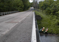
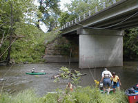
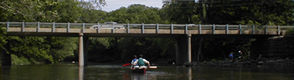
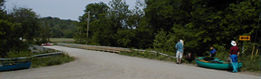
Photos of the Rainsville Bridge access point:
|
||||
Twin Bridges to Quabache Park (Attica Area)This section of the Big Pine Creek is approximately 7 miles in length and requires from 2 1/2 to 4 hours to float downstream of the Twin Bridges area, the creek's character changes. The valley forms a broad floodplain with high walls set back a distance from the stream. After the broad floodplain, Big Pine Creek passes through another steep - walled gorge for approximately three miles before it flows into the Wabash River. Canoeists must cross the Wabash River since the take-out point is on the south side of the Wabash at Quabache Park. This park is located about 2/3 of a mile (approximately 15 minutes) downstream of the confluence of the Wabash River and Big Pine Creek, on the left bank.
The put-in is at Twin Bridges, as previously described, and to shuttle vehicles continue south from the bridge on Twin Bridges Rd./Co. Rd. 025 E until you dead-end into U.S. 41. Turn left (south) and take U.S. 41 across the bridge over the Wabash River into Attica. Make the first right onto Market Street (past the VFW Hall), then turn right onto Canal Street, and dog-leg left, then right to the access site on the Wabash River in Quabache Park. Parking and picnicking are available in the park. Emergency service is located in Lafayette, Williamsport, and Attica. |
||||