Elkhart River (South) in Indiana
| Trip
Reports Check out some nice trip reports! |
Live Streamflow Data | Maps to the Elkhart River (South) Public Access Points |
 |
|
|
The verbiage below was supplied by Indiana DNR's Canoe Guide. The information was last updated at least 16 years ago. Put-in points have disappeared and new ones have formed. It is very important that you submit any trip reports that you have and include what the put-in and take out points look like. With your help we can build a new and improved Indiana Canoe Guide. We will revise the information below as new information presents itself. |
|
If
you have a favorite river, chances are that you know it best. You
can adopt a river for this site, then write about it and describe
the put-in points. You will get full credit and you will be doing
ALL Hoosiers a big favor.
|
The South Branch of Elkhart River is somewhat unusual in Indiana in that it occupies flat, low ground of glacial outwash sediments. Lakes and depressions are connected by this winding river as it makes its way through higher, intermittent moraines (glacial ridges). The topography in the vicinity of the South Branch ranges from low, marshy areas to rolling fields and woods to steep hills.
The flow of the South Branch is perennial, partly due to the large quantity of water coming from ground water reservoirs. The channel varies in depth, is flat and is slow moving. Most of the upland forests of beech-maple and oak-hickory associations along the South Branch have been cleared for agriculture. However, stands still exist where relatively steep, upland slopes drop to the river. Black willow, green and black ash, cottonwood and soft maple occur naturally in the swampy areas, which function as a natural water filter system.
Surveys conducted as part of a 1972 study indicate that the Elkhart River basin contains some of the greatest variety of wildlife and fisheries resources in Indiana. The South Branch of Elkhart River is relatively unique in that the wetlands associated with the South Branch are all in one piece. The river and wetlands become an "island" for migratory waterfowl amongst surrounding agricultural lands. Besides most waterfowl species common to the Mississippi flyway, many other species of birds have been noted, including the great blue heron, little green heron, woodpecker, kingfisher, bittern, rail, coot, gallinule, snipe, sandpiper, killdeer, marsh wren and osprey. In addition, a large variety of mammals thrive in the area: raccoon, deer, muskrat, gray and red squirrels, cottontails, skunks, voles, mice and moles.
River Road to County Road 550 N
This section flows through the Lloyd W. Bender State Nature Preserve. The river is narrow for about the first two miles as it flows through the wooded nature preserve, but it then widens and opens into wetlands. The South Branch flows slowly as it meanders to the northwest. During low water, canoeists may have to portage around or over an occasional downed tree in the channel, particularly in the nature preserve.
This 7 1/4-mile section of the river passes through some of the best remaining examples of wetlands in Indiana and takes approximately 5 hours to float. The float trip on the South Branch requires paddling due to the river's slow flow rate.
The put-in is downstream of the bridge on the right bank, along the right-of-way of Long Lake Road west of Albion. There is only room for parking two cars along the road shoulder. Take care not to trespass on private land. Stay close to the bridge and be cautious of slick areas where the banks become a bit steep close to the river. To drive to the take-out site from this segment, proceed west and south on River Road to the first right. Turn right (west) on North Road and go to the "T" intersection. Turn right (north) on Long Lake Road and drive north crossing the South Branch. After one and one-half miles turn left (west then turn right (north) on the next road. After approximately 3/4 miles you will come to a "T" intersection with North Road. Turn right (east) on North Road and then left (north) on the next road (C.R. 350 W). Proceed north 1 1/4 miles to the next road to the west. Turn left (west) on C.R. 550 N. and cross the South Branch again. The Department of Natural Resources' Fish and Wildlife Division's (Mallard Roost #3) access site is on the left bank, upstream of the bridge. There is plenty of parking spaces at the access site. If a shorter trip is desired, it may be possible to take-out or put-in between the railroad bridge and the C.R. 400 N. Bridge on the left bank, downstream of the railroad bridge.
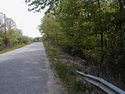
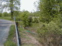
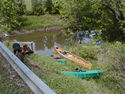
Here are some pictures of the River Road Public Access Point:
County Road 550 N to US 6
This 4 1/2-mile float takes about 2 hours and treats the canoeist to views of extensive wetlands. This segment will take the canoeist through Mallard Roost Wetland Conservation Area, known locally as "the spread." This float begins where the former one ended - at the Mallard Roost #3 access site on C.R. 550 N. There is plenty of parking space at the access site. To get to the Mallard Roost #1 access site, drive east on C.R. 550N. to C.R. 350W. Turn left (north) and proceed to US 6 turning right and then left at the C.R. 600 N. intersection. Turn left (west) on US 6 and drive to the Mallard Roost #1 access site, which is located on US 6 about 3 miles west of Wawaka on the right bank of the river downstream of the US 6 bridge. There is also plenty of parking space at this site. For a shorter trip, the Mallard Roost #2 access site is located on C.R. 600 N. and provides an alternative put-in or take-out site. Emergency medical service is available in Albion.
