Delaney
Park and Spurgeon Hollow Trailheads to Oxley Memorial Trailhead
on the Knobstone Trail in Indiana
(6 to 10 miles)
Description of
Delaney Park and Spurgeon Hollow Loop Trails (supplied by Indiana DNR)
Delaney Park Loop (approximately
6 miles; distance to Spurgeon Hollow Trailhead is approximately 2, 7, or 9 miles
depending on the route chosen) The Delaney Park Trailhead is located inside
Delaney Creek Park, near the beach house. The trail heads east from the beach house
1/4 mile where another trail intersects. At this point, the hiker has a choice:
the trail to the right (southeast) connects to the Spurgeon Hollow Loop (see
description below); continuing straight is the Delaney Park Loop, a rugged 3
1/2-mile hike which connects to the Spurgeon Hollow Loop (following the Spurgeon
Hollow Loop back to the Delaney Park Loop turnoff completes the Delaney Park
Loop [approximately 6 miles]). Following the Delaney Park Loop around to where
it meets the Spurgeon Hollow Loop, the hiker can turn right (west) and continue
2 miles to Delaney Park, or 3 miles to Spurgeon Hollow Trailhead. Turning left
(east), the hiker can follow the south side of the loop around to the Spurgeon
Hollow Trailhead (5 miles) or continue 2 1/2 miles to the turnoff to the Elk
Creek Trailhead. It is approximately 9 miles to the Elk Creek Trailhead from
the turnoff.
Sorry, no descriptions of Oxley Memorial
Trailhead or the sections of the Knobstone Trail adjacent to it are currently
available.
Description of Delaney Park Trailhead
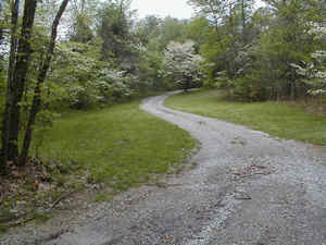
Below is a picture of
the road you need to take to get to the Delaney Trailhead. You will need to
enter Delaney Creek Park and then proceed all the way to the back of the park. Once
you are there you will find several parking spots. The parking spots are on
the grass and they are way back in the back end of the park. The road that you
see below actually loops around, but as you it goes downhill and through a little
tiny streamlet. You will find rowboats for rent, a boat launch facility, a restaurant,
and a campground at Delaney Creek Park, BUT YOU WILL HAVE TO PAY TO GET IN!
Road to Delaney Park
Trailhead
Description of
Spurgeon Hollow Trailhead
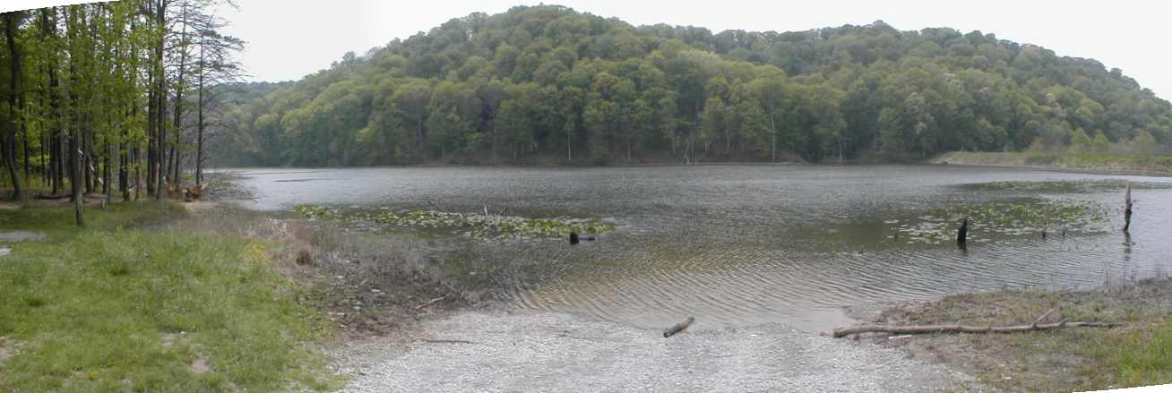
There is plenty of
room to park at the Spurgeon Hollow Trailhead, I took a nice
panoramic picture (80K) of the parking situation. There is a nice little
wooded place to cook out and a decent little boat launch that would be perfect
for a johnboat or other small craft. It looked like a great place to go fishing,
so I took a nice panorama shot of the ramp and the view (below). The water
looked a bit low (imagine that).
Spurgeon Hollow
boat ramp (pic taken on 5-4-2000)
Directions
to Delaney Park and Spurgeon Hollow Trailheads
(supplied by Indiana DNR)
Delaney Creek Park is located about 2 miles east of SR 135 and 9 miles northeast
of Salem; by road it is about 1 mile north of the Spurgeon Hollow Trailhead.
The two trailheads
are located east of S.R. 135 between Brownstown and Salem. To reach the trailheads
from State Road 135, EITHER drive south from Brownstown (17.1 miles from the
S.R. 50 intersection) OR north from Salem (3.8 miles form the SR 56 intersection)
to Rooster Hill Road/Old SR 135. Turn east onto Rooster Hill Road/Old 135,
veer right and follow the road 1.6 miles. Turn right onto Winslow Road, veer
left. and follow the road 0.6 mile. EITHER turn left onto Delaney Park Road
to reach the Delaney Creek Park entrance (0.2 mile), OR turn right to reach the
Spurgeon Hollow Trailhead (0.3 mile). Delaney Creek Park, is operated by the Washington
County Park Board and is connected to the Knobstone Trail. Delaney Park requires
an admission fee for all park users and Knobstone Trail hikers. To proceed
to the Spurgeon Hollow Trailhead, turn right (south) from the Winslow Road/Delaney
Park Road intersection and continue for 1/2 mile to the trailhead entrance
road (gravel) on the left (east)-watch for the "KT" post. Turn left
(east) onto the entrance road to get to the trailhead.
To drive from Delaney Park to the
Spurgeon Hollow Trailhead, turn left (south) from the Delaney Creek Park entrance
road onto the road it intersects and follow for approximately 3/4 mile to the
trailhead entrance road on the left (east)-watch for the "KT" post.
Turn left (east) onto the entrance road (gravel) to get to the trailhead.
Note: Indiana DNR
does not mention directions to Oxley Memorial Trailhead. Look at our detailed
map to the trailheads (above) to see how to get there.