Wesley
Chapel Gulf
in Hoosier National Forest
Wesley Chapel Gulf Area is a 187-acre tract of land located on the Hoosier National Forest in western Orange County, Indiana. The Gulf is approximately four and one-half miles southwest of Orleans and two miles east of Orangeville. It is named for the Wesley Chapel Church, located just to the north. The church was built in 1858, originally known as Bruner's Chapel, and has an associated cemetery.
Wesley Chapel Gulf was designated as a National Natural Landmark in 1972 due to its impressive geologic features. The gulf provides a rare glimpse of the Lost River on its subterranean path. Several other karst features are represented in the immediate area of the Gulf including swallow holes, sinkholes, and caves. The Forest Service recognized the uniqueness of Wesley Chapel Gulf and acquired the property in 1996 through a land exchange with U.S. Gypsum Co.
The gulf has been a subject of local interest for more than two centuries. In the early days it was a source of water supply for the community and was known as the Shirley Gulf. It has also been known as Elrod Gulf. Dating back to the 1930s, numerous scientific studies have been completed on the Lost River system as a whole including the Wesley Chapel Gulf area.
|
|
How the Gulf was formed
A gulf is always associated with an underground stream, and its development is dependent upon the collapse of the rock overhead and the solution and removal of the fallen rock. Gulfs have their beginnings in collapsed sinkholes. When a collapsed feature has its steep-walled perimeter enlarged to such an extent that it possesses a distinct alluviated floor in which an underground stream rises and sinks, it may be called a gulf. The alluviated floor is usually marked by stream-formed channels which pass from the rise to the swallow hole or series of swallow holes where the water is returned to the underground channel system.
The Wesley Chapel Gulf and its deeply alluviated floor of clays and silts indicate approximately 720,000 cubic yards of native limestone have been dissolved and removed. The width of the gulf is far greater than any known section of underground Lost River. The gulf is more than a collapsed cavern whose rock has been dissolved away. The shape of the gulf and its present relationship to the underground water courses suggest the nature and method of its development. It was probably one or more collapsed sinkholes of rounded outline over a broad and weakened portion of the underground system. The collapsed rock obstructed free passage of the water, which caused the water to further undermined the walls around the collapse depression. Further collapse increased the perimeter of the initial depression. If two or three collapse areas formed in a row, their perimeters in time merged to form a large and elongated depression with semicircular ends, such as Wesley Chapel gulf possesses. Horns of rock would extend out in the depression for a time, but eventually would erode away. One such horn of rock, tumbled and broken, still extends into the floor of Wesley Chapel Gulf.
Past Land Uses
The majority of the area has been cleared and grazed when the property was in private hands. Records show the farm included a house, shed, tool shed, chicken coop, pig shelter, an old barn, and a new pole barn. The house was built in 1900 by James and Ellen Hudleson. They sold the farm to James and Effie Elrod in 1909, who made improvements to the land and operated the farm until 1952. This site was not eligible for the National Register of Historic Places and the buildings have been removed after the Forest Service acquired the property. The property was managed as a typical family farm from the 1900s to 1990s. Some of the land was cultivated for crop production. There were 149 acres of old field that are still in an open condition, approximately 30 acres of timber partially located on a ridge, and the 8 acre gulf. The grazing ceased in 1996 when the property was acquired by the Forest Service, and no active management has occured since that time other than custodial care. The former driveway is still in good condition, and offers access and parking to visitors. The neighboring area is agricultural and very rural, with some Amish neighbors using primitive farming methods. Within the gulf are several sinkholes. The majority of the sinkholes had trash including metal, wood, concrete, glass, and household items within them when the Forest Service acquired the property. They were cleaned out and restored to natural conditions in the summer of 1999.
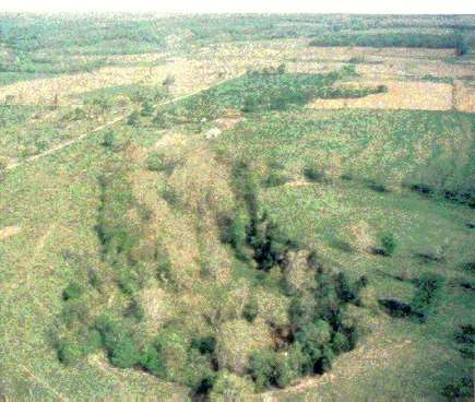
Wesley Chapel Gulf is one of the most impressive geological features along the Lost River. This Gulf is located on a direct line between the main rise (located two miles west) and sink (located 5 miles east) of the Lost River. As a surface feature, the gulf is entirely within the St. Genevieve limestone layer. The Lost River chert, which is near the base of the St. Genevieve, is exposed in places at or just above the level of the alluviated floor of the gulf.
Wesley Chapel Gulf is an abrupt steep-sided depression, which resembles a large peanut shell. The gulf measures 1,075 feet in length and averages approximately 350 feet in width. It includes an 8.3 acre area as measured from the rim, while the floor of the gulf is around 6.1 acres in size. The gulf walls vary in height from 25 feet on the northwest side to approximately 95 feet on the southwest side.
The Lost River rises from a 125-foot rise-pool called Boiling Spring located at the southern end of the gulf. The artesian waters rise from the main subterranean course of Underground Lost River. The rise pit overlies a water-filled opening about 3 feet in diameter that slopes downward to where it intersects a larger passage about 160 feet from the rise pit and about 45 feet below normal pool level. The large passage is 10 feet high, 30 feet wide, and extends northeastward at least 200 feet. The waters in Boiling Spring are forced to rise 20 feet or more from the submerged passage during low-water periods, and as much as 50 feet or more during flood periods. During low-water periods the Boiling Spring pool is 25-30 feet deep, azure blue in color and perfectly calm. The water flows for a short distance, then disappears through the mud-covered talus rock at the base of the south wall of the gulf.
During high-water periods the water increases in volume and becomes muddy and silt-laden as it rises turbulently from Boiling Spring. The pit fills to overflowing and the water is discharged into the flood-water channels. The channels are littered with swallow holes (over 100 have been recorded). Each of the swallow holes is successively filled to capacity. Flood waters primarily enter the underground system immediately south of Boiling Spring rise-pool through chinks in the limestone wall, through other openings in the southern and western walls of the gulf, and through several swallow holes located at the northwest end of the gulf.
Following very heavy rains, the gulf floor may become completely inundated by up to five feet of water. At such times the waters issuing from the pit are violently turbulent and great boils of rising waters discharge from it. As much as 4,000 - 5,000 cubic feet per second issue from the underground course of Lost River. The flood occurs because water enters from the pit faster than it drains out through the numerous swallow holes suggesting the flooding occurs more on account of the limited capacity of the underground channel system west of the gulf than due to the limited capacity of the numerous swallow holes through which the waters escape from the gulf.
There is a hanging valley located on the northeast side of the gulf. Storm waters enter the gulf at this location and have caused the development of a V-shaped notch in the perimeter of the gulf.
The processes which have formed the gulf are still in operation and the growth of the gulf has been progressive. The gulf is a product of perimeter collapse and dissolution of the fallen rock. The enveloping underground streams are vigorous dissolving agents, which continually sap the foundation of the gulf walls. These walls are hollowed out, weak at their bases, and do not stand on solid rock. Over time, 720,000 cubic yards of rock have been undermined, tumbled in, and dissolved away, thereby creating a new level. The streaming waters surrounding the gulf are perpetually working to enlarge it into a lengthening valley expanse. In describing his Wesley Chapel Gulf explorations Dr. Clyde Malott (1932) wrote: "This miserable little stretch of the underground river route gives us but a tantalizing glimpse of a mighty cavern, whose main channel length cannot be less than eight miles. Inadequate as it is, it is a sample of a big cavern in the making... coursed by a dangerous river. It presents a forbidding, mysterious, fearful picture to the senses and it is impressive only when conceived as the underground conduit of a large stream more than eight miles in length and 60 to 150 feet beneath the upland surface which feeds water to it through... nondescript inlets."
Tours
The Orange County Tourism Task Force is interested in this site, and tours are conducted several times a year by Lost River enthusiast Bob Armstrong. For information on tour dates, contact the Orange County Chamber of Commerce at 812-723-4769.
|
||||||||||||||||||||||||||||||||||
 |
||||||||||||||||||||||||||||||||||