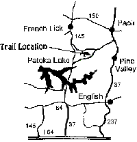
Springs Valley Trail
(in the middle section of Hoosier National Forest in Indiana)


Trip Reports
Currently no trip reports
available
Submit your trip report now!
Detailed Map of
Springs Valley Trail
Maps to
Springs Valley Trail
Outfitters

The multiple-use Springs Valley Trail offers approximately 12.7 miles for hiking, horseback riding and mountain biking. The trail circles Springs Valley Lake (Tucker Lake) and offers scenic views of the lake, as well as remnants of the Buffalo Trace.

Parking for day use is available at the trailhead. The Springs Valley Recreation Area with campground is located on the north shore of the lake. However, horses are not permitted in the campground. Picnic and restroom facilities are located near the Recreation Area and have hitching posts to allow use by all trail users.

The 140-acre Springs Valley Lake is surrounded by scenic hardwood forests. A boat ramp and picnic facilities are also available. No fees are charged for entry, parking, picnicking or use of the boat ramp.

According to a survey by Indiana DNR fisheries biologists in August of 2000 Springs Valley Lake showed good populations of bluegill, redear sunfish, largemouth bass, and channel catfish.

NOTE: Horse riders and mountain bikers are required to have a trail permit and stay on trails designated for their use. Annual ($35/year) and day-use ($5/day) permits are available from Hoosier National Forest offices and several local vendors.

NOTE: According to Indiana DNR visitors to this area should be aware of a vandalism problem in this area and people are asked to report any suspicious activity or damage.

This trail operated by:
US Forest Service
Tell City Ranger District
248 15th Street
Tell City, IN 47586
Phone: 812-547-7051
Hoosier National Forest website


CAMPING INFO

The Recreation Area features primitive camping with vault toilets only. No drinking water is available. No fees are charged. No horses are allowed in the campground.

Other camping and lodging options with more amenities are available nearby.


MOUNTAIN BIKING INFO
Directions:

From Hwy 37 (south of Bloomington and Paoli), go west on CR 550 S / CR 560 S at Pine Valley (at the 2nd sign for Youngs Creek). Continue west approx. 0.8 miles and turn right (north) into the trailhead parking area (which should have a sign reading "FR 707").

From Hwy 145: Take Hwy 145 South out of French Lick 6.4 miles and turn left at brown FS sign on Baseline Liberty Road and proceed 4.8 miles to trailhead on left.

From Hwy 37: From Hwy 37, south of Paoli turn right on Unionville Road, proceed for 1 mile, turn right at brown FS sign onto County Road 150 S. and proceed 1.1 miles to stop sign and turn left onto County Road 225 W, proceed 2.1 miles to brown FS sign and bear left onto County Road 325 W for 4.9 miles to Springs Valley Trailhead on right side of road.

(Check out the maps above too.)

Length: Approx. 12.7 miles
Trail Type: Wide gravel double track
Skill Level: Beginner to Intermediate
Description:

There is a loop trail around the lake, as well as a one way spur trail that splits off from the loop at the far east end of the lake and heads further east. This trail is not at all technical, and is a good trail for beginners.


YIELDING THE RIGHT OF WAY
Since you may be sharing the trails with different types of users, please observe the following trail courtesy:
-
Mountain bikers yield to horse riders and hikers. (Make your approach known well in advance.)
-
Hikers yield to horse riders.
-
Horse riders: control your horse.


Outdoor Resources:
Other Information:
 
www.IndianaOutfitters.com - Indiana's Online Outdoor Recreation Guide