|
 Oriole West offers an approximately
7.2 mile long multiple-use loop trail. Enjoy hiking, horse riding
or mountain biking through scenic hardwood forests. Oriole West offers an approximately
7.2 mile long multiple-use loop trail. Enjoy hiking, horse riding
or mountain biking through scenic hardwood forests.
Horse riders and mountain
bikers are required to have a trail
permit and stay on trails designated for their use. Annual ($35/year)
and day-use ($5/day) permits are available from Hoosier National Forest
offices and several local vendors.
Nearby Oriole
East offers anothers another approximately 8.8-10 miles of multiple-use
trails.
This trail is operated by:
US Forest Service
Tell City Ranger District
248 15th Street
Tell City, IN 47586
Phone: 812-547-7051
Hoosier National Forest website
Oriole
West Mountain Biking Trail Info |
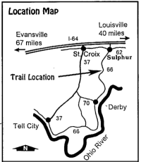
| Directions: |
From I-64 (approx. 40 miles
west of Louisville), take SR 66 South, through Sulphur, approx. 5
miles and turn right
(west) onto CR 52. Continue west approx. 1 mile to the trailhead and
parking area.
(Check out the interactive
map above.) |
| Length: |
Approx. 7.2
miles |
| Trail
Type: |
Single track
& fire roads |
| Skill
Level: |
Intermediate |
| Trail
Description: |
The trail runs through
hardwood forest and is moderate, with some technical sections. Attention
is required on descents and climbs. Go counter-clockwise for a fast,
"whoop-filled" descent that leads into a technical single-track. The
trail includes a scenic creek bottom section and some wide, gravel-covered
stretches. |
YIELDING
THE RIGHT OF WAY |
| Since you may
be sharing the trails with different types of users, please observe
the following trail courtesy: |
- |
Mountain bikers
yield to horse riders and hikers. (Make your approach known well in
advance.) |
- |
Hikers yield
to horse riders. |
- |
Horse riders:
control your horse. |
|
|